Subscribe to Regional Data
The Explorer facilitates seamless exploration of regional data, allowing users to select and scrutinize specific regions effortlessly. Utilizing filters, users can refine their search, obtaining precise information tailored to their requirements.
Subscription View

The subscriptions view in the RoadSense Explorer provides users with a comprehensive interface to manage and monitor their data subscriptions. Users can select specific areas of interest by defining boundaries using coordinates or interactive tools. The view displays key information about active and expired subscriptions, including start and end dates, the size of the selected area, and a detailed map visualization of relevant data points, such as road hazards and traffic patterns. With an intuitive layout and the ability to toggle layers, users can efficiently analyze and explore their subscribed regions, ensuring actionable insights at their fingertips.
Select Region Menu
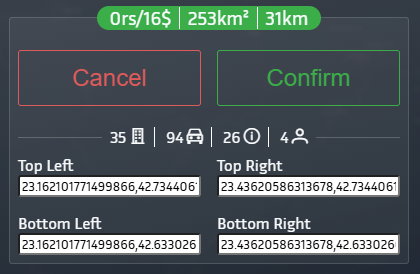
Transparency is a cornerstone of RoadSense, ensuring that customers know exactly what they’re getting when selecting a region. The Select Area Menu provides dynamically updated statistics as you define your area of interest, giving you full control over your choices.
Key Features of the Selection Menu:
- Dynamic Updates: As you adjust your selection, the menu dynamically updates to reflect real-time data and metrics for the chosen region.
- At a Glance (Green Header):
- Region Cost (USD): The calculated price for the selected area.
- Selected Region Area: The total area size in square kilometers.
- Mapped Road Length: The total road network length within the selected region.
- Detailed Stats (Below Confirmation):
- Government Records: The number of official records available for the area.
- Driver-Collected Data: Contributions from users actively collecting data on the roads.
- Road Status Records: Data points highlighting the current condition and updates for the road network.
- Unique Contributors: The number of distinct users who have contributed data to the selected region.
Pricing Model
The cost of a region is calculated based on the richness and freshness of the data. Regions with higher coverage and recent updates may have a higher price, reflecting their greater utility and relevance compared to areas with sparse data.
Subscriptions List
The Subscriptions tab in the dropdown menu provides users with a detailed overview of all their subscriptions. Each subscription card contains essential information, such as the region area, subscription ID, and start and end dates. Additionally, the cards feature two colored tag boxes at the top, each serving a specific purpose:
- Subscription Status The first tag (left) displays the current status of your subscription. The possible statuses include:
- Active: Your subscription is active, and no further action is required.
- Payment Processing: Your payment is being processed by our payment provider. Transactions typically complete within a few minutes.
- Expired: Your subscription has ended, either because automatic billing failed or you canceled it through the
Manage Plans Portal. You can still view your purchased region, but data will only be available up to the end date. New data collected after this date will require renewing your subscription. - Error: An error occurred during the subscription creation process. No money will be deducted from your account. You can try creating the subscription again after some time. If the issue persists, please contact support for assistance.
Tip: If your previous subscription has expired, you can easily renew it. Click the three dots in the top-right corner of the subscription card and select the
Renew Subscription option. This will reselect the same region and prompt you to re-subscribe.
- PMTiles File Generation Status The second tag (right) indicates the status of the PMTiles file generation. What are PMTiles? PMTiles are optimized map data files that enable fast and efficient delivery of the road data you need. Each time you create a subscription, a PMTiles file is generated specifically for you on our servers. The status of this process is displayed in the tag and includes:
- Completed: Your data file has been successfully generated and is ready for use.
- Initial: File generation is pending until the payment is processed.
- Processing: The file is currently being generated.
- Error: An error occurred during the file generation process. You can manually attempt to regenerate the file by clicking the three dots in the top-right corner of the subscription card and selecting the
Regenerate Files option.
Tip: If you have an active subscription, it’s a good idea to regenerate your files periodically to ensure they are up-to-date with the latest data added to RoadSense.
Data Details of a Subscription
 The Data Details view for a subscription provides an in-depth overview of all collected data within the selected region. Key statistics include the number of government records, road status data points, and driver-collected data. Additionally, users can explore today's events, the unique kilometers mapped within the last 24 hours, and the number of contributors who have added data recently.
This interface also allows users to inspect each record individually, displaying its precise location on the map and associated metadata for deeper analysis. For example, events such as potholes are listed with timestamps and are visually represented on the map for easy identification and context. This granular approach ensures that users have full visibility into the data powering their subscriptions.

Try our 7-day free trial and start exploring the possibilities. Not sure yet? Dive into our digital twin of Bulgarian road infrastructure for FREE and see the difference it can make for you!